Art Custom Framing Gallery Los Cabo San Lucas, San Jose del Cabo, Mexico

 |
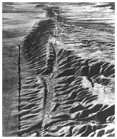
The San Andreas Fault is a geological fault that runs a length of roughly 800 miles (1,300 km) through western and southern California in the United States. The fault, a right-lateral strike-slip fault, marks a transform (or sliding) boundary between the Pacific Plate and the North American Plate.
The fault was first identified in Northern California by UC Berkeley geology professor Andrew Lawson in 1895 and named by him after a small lake which lies in a linear valley formed by the fault just south of San Francisco, the Laguna de San Andreas. Following the 1906 San Francisco Earthquake, it was Lawson who also discovered that the San Andreas Fault stretched well southward into Southern California.
Scientists have learned that the Earth's crust is fractured into a series of "plates" that have been moving very slowly over the Earth's surface for millions of years. Two of these moving plates meet in western California; the boundary between them is the San Andreas fault. The Pacific Plate (on the west) moves northwestward relative to the North American Plate (on the east), causing earthquakes along the fault. The San Andreas is the "master" fault of an intricate fault network that cuts through rocks of the California coastal region. The entire San Andreas fault system is more than 800 miles long and extends to depths of at least 10 miles within the Earth. In detail, the fault is a complex zone of crushed and broken rock from a few hundred feet to a mile wide. Many smaller faults branch from and join the San Andreas fault zone. Almost any road cut in the zone shows a myriad of small fractures, fault gouge (pulverized rock), and a few solid pieces of rock.