Art Custom Framing Gallery Los Cabo San Lucas, San Jose del Cabo, Mexico

 |
|
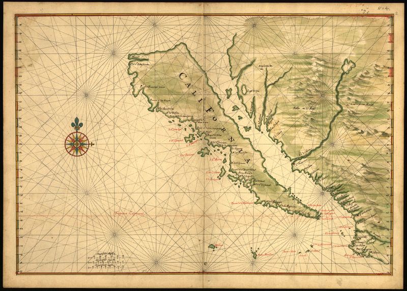
Island of California 1600's
|
Most famous map error in history
The Island of California refers to a long-held European misconception, dating from the 16th century, that California was not part of mainland North America but rather a large island separated from the continent by the Gulf of California.
One of the most famous cartographic errors in history, it was propagated on many maps during the seventeenth and eighteenth centuries, despite contradictory evidence from various explorers. The legend was initially infused with the idea that California was a terrestrial paradise, like the Garden of Eden or Atlantis.
History
The first known mention of the legend of the "Island of California" was in the 1510 romance novel Las Sergas de Esplandián by Garci Rodríguez de Montalvo — the sequel to Montalvo's more famous tales of Amadis de Gaula, father of Esplandian. He described the island in this passage:
Know, that on the right hand of the Indies there is an island called California very close to the side of the Terrestrial Paradise; and it is peopled by black women, without any man among them, for they live in the manner of Amazons
It is probable that this description prompted early explorers to misidentify the peninsula of Baja California as the island in these legends.
In 1533, Fortún Ximénez, a mutineer on an exploring expedition sent by Hernán Cortés, discovered the southern portion of Baja California, around La Paz. Cortés himself followed up on the discovery with an expedition to La Paz, but the settlement had to be abandoned soon afterwards. Cortés' limited information on southern Baja California apparently led to the naming of the region after the legendary California and to an initial but short-lived assumption that it was a large island.
In 1539, Cortés sent the navigator Francisco de Ulloa northward along the Gulf and Pacific coasts of Baja California. Ulloa reached the mouth of the Colorado River at the head of the Gulf, which seemed to prove that the region was a peninsula rather than an island. An expedition under Hernando de Alarcón ascended the lower Colorado River and confirmed Ulloa's finding. Maps published subsequently in Europe during the sixteenth century, including those by Gerardus Mercator and Abraham Ortelius, correctly showed California as a peninsula.
Despite this evidence, however, the depiction of California as an island revived in the early seventeenth century. One contributing factor may have been the fictitious exploits of Juan de Fuca in 1592. Fuca claimed to have explored the western coast of North America and to have found a large opening that possibly connected to the Atlantic Ocean — the legendary Northwest Passage.
A key role in changing ideas about California seems to have been played by an overland expedition led by the founding governor of New Mexico, Juan de Oñate. The expedition descended the Colorado River in 1604-1605, and its participants believed that they saw the Gulf of California continuing off to the northwest (presumably behind in the Sierra Cucapá into the Laguna Macuata Basin).
Reports from Oñate's expedition reached Antonio de la Ascención, a Carmelite friar who had participated in Sebastián Vizcaíno's explorations of the west coast of California in 1602-1603. Ascención was a tireless propagandist in favor of Spanish settlement in California, and his later writings referred to the region as an island.
The first known reappearance of the Island of California on a map dates to 1622 in a map by Michiel Colijn of Amsterdam. The image became the standard for many later maps throughout the seventeenth century and intermittently into the eighteenth century.
The Jesuit missionary and cartographer Eusebio Francisco Kino revived the idea that Baja California was a peninsula. While studying in Europe, Kino had accepted the insularity of California, but when he reached Mexico he began to have doubts. He made a series of overland expeditions from northern Sonora to areas within or near the Colorado River's delta in 1698-1706, in part to provide a practical route between the Jesuits' missions in Sonoran and Baja California but also to resolve the geographical question. Kino satisfied himself that a land connection must exist, and the eighteenth century Jesuits generally followed his example. However, Juan Mateo Manje, a military companion on several of Kino's treks, had his doubts, and European cartographers remained divided on the question.
Jesuit missionary-explorers in Baja California who attempted to lay the issue finally to rest included Juan de Ugarte (1721), Ferdinan Konščak (1746), and Wenceslaus Linck (1766). The matter was settled beyond all dispute when the expeditions of Juan Bautista de Anza traveled between Sonora and the west coast of California in 1774-1776.
Due to tectonic plate movement, in approximately 25 million years, Baja California and part of Southern California will separate from the mainland and continue drifting in a somewhat northward direction. This gradual movement (interspersed with occasional halts and earthquakes) will eventually serve to place Los Angeles north of San Francisco some fifty million years from today.